 |
by Wolfgang
Knorr and Peter Cox
CAMELS is an EU funded project on "Carbon Assimilation and
Modelling of the European Land Surface", forming part of the CarboEurope
cluster of projects. The aims of CAMELS
are to produce:
- best estimates and uncertainty bounds for the contemporary
and historical land carbon sinks in Europe and elsewhere, isolating the effects
of direct land-management.
- a prototype carbon cycle data assimilation system (CCDAS)
exploiting existing data sources (e.g.
flux measurements, carbon inventory data, satellite products) and the
latest terrestrial ecosystem models (TEMs), in order to produce operational
estimates of "Kyoto sinks".
It is designed to address important questions concerning the
global and European carbon cycle from a combined data and modelling point of
view. As one of the CarboEurope projects starting towards the end of the 5th
Framework Programme, it capitalizes on the rich data findings of the project
cluster by integration into a consistent modelling framework, using several
European state-of-the-art ecosystem models. Scientific questions addressed
include:
·
Where are the current carbon sources and sinks located on
the land and do European sinks compare with sinks of other large continental
areas?
·
Why do these sources and sinks exist, i.e. what are the
relative contributions of CO2
fertilisation, nitrogen deposition, climate variability, land management
and land-use change?
·
How could we make optimal use of existing data sources and
the latest models to produce operational estimates of the European land carbon
sink?
The first question has up to now been addressed by two
major approaches, one with a bottom-up, and another with a top-down view.
Bottom-up modelling uses data from the field and basic process understanding in
carbon cycle and plant physiology to compute CO2 fluxes between the
land and the atmosphere. The top-down approach uses atmospheric measurements in
combination with an inverse atmospheric transport model to infer the same
quantity. In addition, CarboEurope and other international projects have
created a wealth of information on locally measured CO2
and water exchange fluxes at the stand level.
The advantage of the top-down, atmospheric inversion
approach is that it relatively little prior information on flux patterns enters
the calculation (but biosphere model results are often used to generate prior,
"first guess" fluxes), and that it works on large scales. Its main disadvantage
is relevant to the second question above: there is no information gained
concerning processes. The advantages of the bottom-up approach are
complementary: it can make use of process knowledge, is thus able to distinguish
between natural and management effects (required under the Kyoto protocol, for
example), and can be used prognostically. Its disadvantages: it is often
uncertain, there are large data gaps, and it cannot make optimal use of
large-scale constraints.
CAMELS uses a novel approach, termed Carbon Cycle Data
Assimilation System (CCDAS), that combines both views and adds a few additional
elements. An additional innovation is that CAMELS produces consistent
uncertainty bounds on carbon fluxes that are essential for policy purposes. It
starts from flux measurements at the stand scale, which are used to improve and
best parameterise a number of ecosystem models. The exercise also yields
uncertainty bounds for ecosystem model parameters, and, by using data from all major
biomes, a notion of the representativeness of the models and parameterisations.
The assumption used in CAMELS is that the best way to
spatially extrapolate the results from the flux measurements is not through
fluxes, but through parameter values that describe the underlying processes.
Hence, the parameter values optimised from the site data are used as a priori values in a global carbon cycle
data assimilation system (CCDAS). CAMELS has so far produced one prototype
CCDAS based on the ecosystem model BETHY: in a first data assimilation step,
BETHY takes satellite-observed values of "greenness" to optimise parameters
related to water status, phenology, and total plant cover. Next, the adjoint
(the first derivative of the code with respect to model parameters) of the
physiological and energy balance part of BETHY coupled with the adjoint of the
atmospheric transport model TM2 is used to optimise parameter values of BETHY.
This is done by assimilation of atmospheric CO2 concentration
measurements. Uncertainties of optimised model parameters can be derived from
the Hessian (the second derivative) of the BETHY code with respect to the
parameters. By using the Hessian of the BETHY code with respect to the
parameters, uncertainties of optimised model parameters can also be derived.
These uncertainties, that reflect both the prior information (in a Bayesian
context), as well as the information from the large-scale inversion, can
finally be translated into uncertainty bounds for CO2
fluxes and any other model diagnostic. Both the adjoint
and Hessian codes are generated automatically using the compiler tool TAF,
developed by FastOpt. Automatic generation ensures that improvements of BETHY
can be used in the assimilation scheme without delay.
First results with CCDAS using 20 years of CO2
observation from the free atmosphere, while still somewhat preliminary, clearly
show that interannual fluctuations of terrestrial CO2 fluxes are
dominated by the El Nińo-Southern Oscillation (ENSO) cycle, except for the time
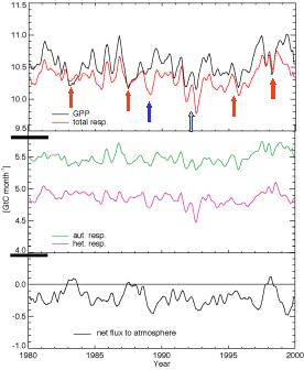
after the Pinatubo eruption (Scholze, 2003). During El Nińo (warm) pacific
conditions, large parts of the tropical ecosystem come under water stress with
reduced photosynthesis (see Figure 5.6.1). Of the 58 parameters that enter the
optimisation, considerable reduction in uncertainty is found for about 12
(Figure 5.6.2). We find a terrestrial sink for Europe (excl. Russia) that is
around a third of the fossil fuel emissions of the area, but with uncertainty
bounds of the same size as the fluxes themselves. The country analysed that has
the largest uncertainty in terrestrial CO2 fluxes is Brazil, mainly
because of the lack of observation stations in that area (Scholze et al., 2002, Figure 5.6.3).
Building on the experience gained with CCDAS, CAMELS is
currently working on a series of historical ecosystem model simulations that
span the entire 20th century and that include further processes,
such as land management and nitrogen deposition. The final aim is to present a
concept for an operational system that is able to optimally combine all
relevant large-scale observations to deliver the best possible estimates of
European and global CO2 fluxes on a routine basis. Further
information about CAMELS is available form http://www.bgc-jena.mpg.de/public/carboeur/projects/camels.htm; for CCDAS
please check the website http://www.ccdas.org. Members of the the CCDAS
consortium are Marko Scholze, Wolfgang Knorr, Heiner Widmann (Max-Planck
Institute for Biogeochemistry, Jena), Peter Rayner (CSIRO, Melbourne),Thomas
Kaminski and Ralf Giering (FastOpt, Hamburg).
Figure
5.6.1: Time
series of global monthly fluxes prognosed from CCDAS smoothed with a five month
running mean filter, after subtracting average seasonal cycle. Red/blue arrows:
exception El Nińo/La Nińa events, yellow arrow: Pinatubo eruption.
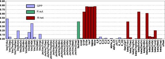
Figure
5.6.2: Reduction
in uncertainty, expressed as 1-sprior/soptimized., for the 58
parameters of BETHY used in CCDAS.
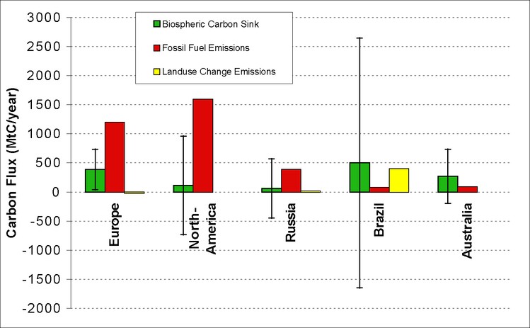
Figure
5.6.3: Estimated
biosphere carbon sink strength and associated uncertainties compared to fossil
fuel and land use emissions for 5 regions.